Calibration : Where it all Started
A real student lead course, Geography at the University of Worcester puts you first! Due to the lecturers having a real passion for what they teach it allowed me to find my niche – Drones. This was kick-started from one Phantom 4 Pro demonstration in a Level 4 module of my undergraduate degree.
Take-off : How it Grew
Knowing that my passion lay with drones, I actively sought for as much experience as possible.
Learning and Teaching Project
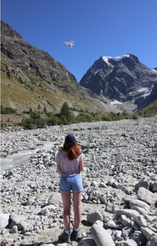
Through a competitive selection process I was chosen to participate in a funded project to aid future students. The project involved travelling to the Swiss Alps to collect drone imagery to be used in practical classes in Level 5 modules. Behind the scenes work for this required: identification of new and suitable sites within the Arolla Valley, obtaining baseline data at each site including the distribution and surveying of GCPs and IVPs with a as well as being a co-pilot for numerous Phantom 4 Pro with onboard RTK flights!
Fieldwork Assistance
If, when and how I could participate in drone fieldwork, I did.
This began with assistance on Masters and PhD students projects. For this I undertook tasks such as laying and surveying GCPs with the Trimble R10 GNSS, setting up and calibrating the drone before flight, experience with the DJI Go App and undertaking supervised flights.

From this my fieldwork experience took off- the most memorable being in the Arolla Valley 2020. Myself and two fellow students on my course aided Senior Professor Ian Maddock in his study of using a Phantom 4 Pro with onboard RTK to measure snow depth. Although the week-long excursion involved a lot of perseverance; walking through 2m snow with non-waterproof boots (not my best idea) and thinking on the spot with the kit constantly failing due to the extremely cold temperatures, it was a lot of fun! I was able to get some incredible flying experience in a totally new environment with people that shared the same passion, this made it all worthwhile.
Student Academic Partnership
Student Academic Partnerships involve a close relationship between lecturers and students to create a project beneficial to all. Our project involved a practical session in the form of a powerpoint, interactive exercises and quizzes to equip undergraduate Geography students with the
knowledge to pass the CAA Drone Safe Drone Code test. Noting the importance of this, we sought to make the practical as fun and inclusive as possible, hoping these key practices stay in their minds for future flights! Due to the current COVID-19 crises the practical has not been implemented, however, I look forward to hearing about its potential success in upcoming years.
Dissertation
Your independent study is all about expressing yourself in your field of expertise- for myself this was a no brainer. My project was titled: Assessing the effectiveness of drone imagery in identifying Channel Geomorphic Units. Undertaken upon a 200m sinuous reach of the River Teme, I conducted supervised flight with a Phantom 4 Pro using a flight plan I generated myself through the DJI Go App. Although this sounds smooth sailing… as with all flights unexpected problems can arise. The growing issue with shared airspace was apparent when I had to quickly move the university drone out of the way of an oncoming military helicopter. Avoiding any near-misses and on return to the office I was able to freely process my dataset of 720 photos in Agisoft Metashape Pro creating fully referenced and high quality orthophotos and DEMs.
Work Placement
A very big step in my UAV career progression was my work placement at Geodime. The placement allowed me to transfer my educational knowledge of UAVs into a working context- meeting real and tight deadlines. My role at Geodime was ‘ Assistant Pilot and Photogrammetrist which saw me working closely with large scale companies such as Hanson, to generate their monthly stock surveys. To achieve this I performed supervised drone flights and processed any datasets through complex softwares such as Klau.

Flight: My Next Steps
Since graduating from the University of Worcester in Summer 2020, I wanted to turn my experience with UAVs into a career. Personally, I couldn’t have found anywhere better than DronePrep to start. It is clear we share the same passions, the want to be a part of this ever changing discipline by helping their integration both safely and effectively into modern society. I look forward to my part in this mammoth task, opening up the airspace bringing landowners and the drone community together.
DronePrep: Preparing the world for a future with drones.