Preparing the world for
a future with drones

Airwards – Drone Awards
CELEBRATING THE FUTURE OF UAVs

The first global digital awards scheme of its kind to recognise positive drone use cases which are
innovative, safe and have real world implications.

We are thrilled to be working with our partner Airwards who are on a mission to recognise and award innovative, responsible, and impactful drone use cases around the world.

The submissions deadline for the awards is 12th March, so get submitting to the variety of categories available: https://www.airwards.online/categories-main

There’s even a People’s Choice you can get involved in: https://www.airwards.online/categories-main#peoples-choice

We are excited to see all the fantastic examples of how drones are being used positively around the world!

What is Greenspace?

One of many layers on the DronePrep map, Greenspace is a dataset from Ordnance Survey and is designed to depict the location and extent of spaces such as parks and sports facilities that are likely to be accessible to the public.

These areas include:

  • Public parks or gardens
  • Play spaces
  • Golf courses
  • Sports areas or playing fields
  • Churchyards or burial grounds
  • Allotments or community growing spaces

Why is this useful?

Some areas of Greenspace may provide good flying locations with interesting features or just an open space for flying practice.

As well as Landowner information, we’ve also added a Local Authority layer to our map; if a council has a drone policy we’ll show this in the side bar, if not, we provide contact details for you to seek permission.

Flight Restriction Zones

Flight restrictions around aerodromes

Flights of unmanned aircraft around aerodromes that are designated as ‘protected aerodromes’ are restricted. Unmanned aircraft of any size must not be flown within the Flight Restriction Zone (FRZ) of a protected aerodrome, without appropriate permission.

(https://www.caa.co.uk/Consumers/Unmanned-aircraft/Our-role/Airspace-restrictions-for-unmanned-aircraft-and-drones/)

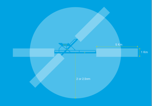
The Flight Restriction Zone consists of the following three elements:

  • A zone with the same dimensions as the Aerodrome Traffic Zone: A 2 or 2.5 nautical mile radius ‘cylinder’ around the aerodrome, extending 2000 ft above ground level, centred on the longest runway.
  • Runway Protection Zones: A rectangle extending 5Km from the threshold of each runway away from the aerodrome, along the extended runway centreline, and 500m either side – also to a height of 2000 ft above ground level.
  • Additional Zones: In the case where a line that is drawn 1Km beyond the boundary of an aerodrome extends beyond the Aerodrome traffic zone, and so would not be protected by it, the flight restriction zone will include a ‘bump’ (the airfield boundary + 1KM) to protect this part of the aerodrome.

The exact shape of the Flight Restriction Zone varies depending on the specific aerodrome that it protects. Prior to flight, remote pilots should check to ensure that they are operating well outside these areas.

Flight Restriction Zone

You can check this on the DronePrep map

Permission must be obtained from the relevant person before an unmanned aircraft may fly within a Flight Restriction Zone. This person is usually whoever is ‘in the Tower’ (i.e. an Air Traffic Controller or Airfield Flight Information Service Officer’. If neither of these is available, because the airfield has closed or there was no ATC/AFIS provision in the first place, then permission must be sought from the Aerodrome Operator.

Contact details are also shown on the DronePrep map

You can read more on the CAA’s website: https://www.caa.co.uk/Consumers/Unmanned-aircraft/Our-role/Airspace-restrictions-for-unmanned-aircraft-and-drones/