Preparing the world for
a future with drones

Bristol Mapup

Last night was the inaugural Bristol Mapup – Organised by Wilfred Waters.

Wil is a mapping expert, having worked as a geospatial analyst since 2008: first in Australia, then Cambodia, Kuwait and Qatar. He has been published in the Journal of Spatial Information Science (JOSIS) and has founded “mapups” in each of these countries. Having recently moved to Bristol, this new spot would be no exception.

What’s a Mapup?

Mapup

/mæpʌp/

noun : mapup; plural noun: mapups

1. an assembly of people who work or have interest in the Geospatial sector, especially for a relaxed discussion to share ideas and experiences.

Mapups are set up to discuss the past, present and future of maps – with topics covering everything from historical expeditions, to modern mapping technology, to the philosophical debates around the power of maps.

Geospatial forums such as this one offer a unique opportunity for enthusiasts, experts and business leaders to keep up with the latest trends in mapping.

Wil invited DronePrep along to his first Bristol Mapup after finding us through Engine Shed – we have been fortunate enough to be affiliated with Engine Shed (An event venue, office, and coworking space in Bristol) through Geovation DronePrep was on Cohort 8 of the Geovation Accelerator Programme, backed by Ordnance Survey and HM Land Registry, which is currently open for applications!

There’s an incredible community of geospatial fans, software engineers, startups founders and creators in both hubs – definitely worth looking into if you want to learn more about GeoTech startup life.

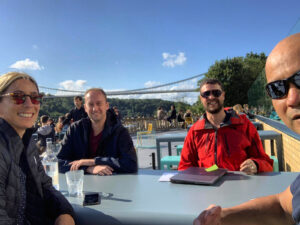
It was a relaxed, sunny and very windy(!) evening on the terrace overlooking the iconic Clifton Suspension Bridge in Bristol, with some excellent GeoChat.

Topics included; how we got the idea for our business, product or project, which ones we’re particularly proud of, how we raised capital / got the idea off the ground and really importantly, the viability of the geospatial startup scene in Bristol. 

“It’s really important for us to keep up to date with the latest and greatest in GeoTech as we plan, scope and deliver on our own software enhancements. The DronePrep Map is a new product, but we’ve big plans for new features and additional products.”

Big thanks to Wil for the invite – we’re very much looking forward to the next mapup!


Are you working in the Geospatial industry or have a keen interest? Do you live/ work in or near Bristol? Get in touch and join us at the next mapup.

DronePrep’s Claire Owen Nominated for Women in Tech Awards 2021

We are excited to announce that DronePrep’s Claire Owen has been selected as a finalist for the Midlands Women in Tech Awards 2021.

Claire has been nominated for the Innovator Award, which is “…awarded to a woman designing, developing, researching, implementing or being exceptionally creative with technology in an unconventional and innovative way.” 

Every vote counts in the race to first place – please head over to the website and vote for Claire:

https://www.womenintechawards.co.uk

Zero to 400, Part 2: Getting a Flyer ID

Zero to 400

Zero to 400 is a record of my journey from casual observer to (hopefully) confident drone pilot. This isn’t a detailed guide to legislation, and I’m certainly no expert on the ever-changing world of drones. I hope these posts can serve as a guide to the novice pilot and answer the basic questions from anyone interested in drones.

Part 1Part 2Part 3Part 4

Getting my Flyer ID

Let’s start with a caveat: I’m not planning to buy a drone right now. I just packed up my life abroad, moved 5,000 miles during a pandemic and bought a car, all in less than two weeks. Any further big decisions are postponed until the dust has settled on the current ones.

Fortunately, my lovely colleagues and friends around the industry have plenty of drones to play around with, so I just need to get myself a Flyer ID – the driving license of droning.


Preparing for the Test

The CAA’s website tells me that in order to get my Flyer ID, I’ll need to pass a 40-question multiple choice test. The test has a pass mark of 30 (75%) and should take around 30 minutes to complete. I can retake the test as many times as I like, so there’s not much pressure there.

Before beginning, I take a quick look back at the Drone Code to see what I can remember from the first read-through.

I enter and verify an email address, and am asked whether I need to register for an Operator ID also – not today!


Taking the Test

The test itself is very much like the Drone Code – a lot of common sense and some pretty straight-forward answers.

There are a few questions designed to make you think twice – especially those that refer to scenarios with several different drones of different classes. Some of the questions end up reading like a school math test (“John has a 2kg drone, and Sarah has a 5kg drone, they are flying within 200m of a built-up area…”). I noticed for a few of these questions the figures are relevant, but for some the figures are just designed to throw your off (e.g. all of the pilots are flying legally/illegally).

Some of the questions encourage you to consider the reasons behind an answer (No, because… Yes, because…) and you’ll need to get that part correct too. Imagine I ask you something like: “Should I fly my drone within 20m of a school playground?” and you are offered the answers: “No, because the kids might steal your drone” vs. “No, because flying within 150m of a built-up area is not permitted” – you get the idea.

It takes less than 10 minutes to complete and – would you look at that – a perfect score of 40/40!


Receiving the Flyer ID

I’m asked to enter in some further details – name, address, phone number (optional) and my Flyer ID is generated immediately and emailed to me.

It’s noted both on the ID and within the confirmation email that I can fly under the A1 and A3 subcategory – that’s the “basic, low-risk flying” for those of you who haven’t studied the Drone Code yet.

My colleague tells me that if I want to fly in higher-risk categories, I’ll need to complete further training – I guess that’s next on the list!

Landowner Permission

Even with a good understanding of the regulations, it’s important to check for bylaws or local restrictions when you fly your drone. Check out The DronePrep Map for everything you need to plan flights safely.

DronePrep Map

Spotlight On: Stu Logan, Unmanned Air Veterans

Following an extensive career in military drone use, Stu Logan and business partner Tom Hubbard launched Unmanned Air Veterans Ltd. Working on a range of projects, from film shoots, to construction, to warehouse inspection, Stu is working to connect with other veterans and improve drone education and perception.

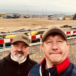
What is Unmanned Air Veterans’ mission?

Our mission – as corny as it sounds – is to be the best that there can be. We are a drone service offering creative media, inspection, analytical work, and movie/TV work. We also run an online group to connect with other veterans involved in drones, so we can talk and share ideas. There are a few of us, all involved in different areas of the industry, and as our business grows, we’re keen to get more involved in the education and training side also.

How did you get involved in drones?

Both myself and Tom served in what was the premier drone regiment in the world. When I joined, the kit was basic, nothing was in real time and there were no live feeds – then as technology improved, I was involved with all sorts of trials and the use of more and more semi-autonomous kit. It was a very colourful, entertaining, and challenging twenty years, and when I finished my service I thought – right, that’s what I’m going to do. Although we served in the same regiment, Tom and I were in different units, so we didn’t know each other too well. It wasn’t until we got out and we bumped into each other by chance. A guy I played football with happened to be working with Tom, so I knew he was in the area, and then a week later while I was out walking the dog, I ran into him taking his daughter to work. We haven’t looked back since

What kind of work are you involved in?

It’s been really varied. Ten years ago or so, you started seeing aerial shots with drones on TV, Film and music videos, the nice stuff. Then on sports, especially golf. Mainly because it’s cheaper than getting a helicopter. I think we had this idea that we’d film loads of golf courses in the UK – and we have done some golf courses – but the industry has changed so much in the last few years that we’re having to adapt all the time. Transport of goods and warehouse work (virtual tours) are two areas we’re starting to see more and more interest in. Construction and mapping are growing really quickly too. I would say that movie work is where we’ve personally been quite lucky, and is something we can really get into and there are projects on the horizon for us. Our first job was actually for an indie horror flick, and working on that was a real “pinch yourself” moment. Note: You can see the trailer for KARLI here: https://youtu.be/k2z9dK5SBXU

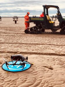
How does commercial work with drones differ from military operations?

I would say the biggest challenge is not necessarily about finding or doing the work, it’s more about the restrictions that we didn’t used to have. We always operated on a “get that done yesterday, do this now” kind of approach, everything’s very quick, whereas now we have to wait around to do jobs. We can get itchy feet while waiting!

How can drones help veterans?

When you transition out of the forces, you can feel like there’s something missing – a kind of sense of self-worth, of being a part of something. We have both gone through our own channels to get help with diagnosed PTSD, but we found that doing something that you really enjoy for a business, having something to focus on, it really helps with that feeling of self-worth. It’s important to give that opportunity to people like myself and Tom who struggled with the transition, and helping people in similar situations lets us give something back to society.

You mentioned education and training. Can you tell me a bit more?

We’ve been invited to local schools to do open days. We did an event with an SEN (Special Educational Needs) school. Some of the teenagers had severe ADHD, Asperger’s, and other learning difficulties, but they were really interested. There was one young lad who came to see the kit, and his carer came up to me after and said – this is the longest I’ve seen him static, doing something and fully engaged – and the feedback was really good. In the future, we want to introduce drones properly to GCSE-age students and to show that this could be a real career route, to encourage work experience opportunities. Longer term, we would love to offer training courses so people can really get to learn all the skills you need to be a drone pilot. I have an idea for this, hopefully in the next 5 years it will happen.

What are your hopes for the future of the industry?

I would like the negative stigma associated with drones to go away. I want people to not be afraid of the industry. People worry over safety, the invasion of privacy, flying over peoples’ gardens and that kind of thing, which is understandable. I think to get there, we need to see a mix of community engagement, hearts and minds, and also more clamping down on people that are being irresponsible. There needs to be some clarity on who to speak to if there is an incident, who is going to enforce the laws. It will make people feel a lot safer. We in the industry also need to be out there making videos and using social media to help the public see what’s going on. I love sharing positive news about drones, and it’s important to show people outside the industry that drones are being used for good.

Find out more:
For more about Unmanned Air Veterans, check out their Facebook and LinkedIn pages.

View from Above: Chris Gorman takes on Plymouth

DronePrep’s Pilot in Residence Chris Gorman, aka The Big Ladder Photographer, uses the DronePrep Map for planning aerial photoshoots. Chris just finished an assignment in Devon for the National Lottery Heritage Fund, resulting in this remarkable image of the sunset in Plymouth.

A new dawn for Plymouth. The brief from the Lottery Heritage Fund was simple:

“We’d like a beautiful sunrise or sunset image of Plymouth to send out to media to illustrate our announcement that the city is to be given a £10m grant to help create the UK’s first National Marine Park”.

A simple brief you may think. However, I had just one day to shoot, meaning weather forecasts and permissions needed to fall in line within 36 hours. Sunrises and sunsets aren’t a given, and considering how awful the summer weather has been so far this year, I knew I may struggle.

My first port of call (no pun intended) was the Port Authority and the local council for permission to fly in the Plymouth Sound area. This was the simple part if I’m honest, as the council were most helpful in granting permission straight away after providing all the relevant documentation.

The hard part was the weather.

I arrived in Plymouth to completely grey skies, despite all three of my weather apps forecasting sunshine. The final image you see here was the only time I saw the sun in 36 hours in the town. The shoot was supposed to take place the following day, but I had this sneaking feeling the sun might put in a brief appearance at sunset.

The time of sunset collided with the England-Denmark match, which partially helped as the Sound was near-deserted due to everyone watching the game. All through the very tense first half of the football, I dashed back and forth to the window to check out what the sun was doing. At halftime, I checked once more and, to my amazement, the sun was out in a blaze of glory for the first time that day. I gathered by gear and ran to my pre-arranged take off spot.

I know from experience that a good sunset can last just seconds, which is why DronePrep’s Daylight Tool is so useful when planning these shots. The last hurdle to jump came from the drone itself, which refused to calibrate the gimbal on first start up… This always involves a drone restart, which takes 40 seconds to complete each time. I could see the picture drifting away in front of me…
Suddenly, on the 3rd start up, the drone finally played ball. I launched and immediately took this shot (which is actually a 5-frame HDR blended in Photoshop). This image saved the entire assignment, as the sun didn’t show its face again. And I didn’t miss a single goal in the football!

The resulting image appeared on BBC News, The Daily Express, The Daily Star and various local media.

Check out more of Chris’s work at www.bigladder.co.uk