Preparing the world for
a future with drones

What’s on the DronePrep Map?

It’s holiday season, so with many of our friends and colleagues away, we decided to skip Spotlight On for this month and instead talk datasets with Claire Owen, co-founder of DronePrep. With a background in property and land data, Claire has a wealth of experience in data aggregation, and her passion for software has been the driving force behind the DronePrep Map.

What can I see on the map?

The map has a number of different layers with so much you can use to plans drone flights. There’s data from HM Land Registry, Ordnance Survey, Esri, what3words, NATS, and custom DronePrep data layers too… There are a few standard things that you see on most drone maps – FRZs etc – but the exciting stuff for us is the land ownership data, local authorities, bylaws, and the ability to plan future flights with the drawing tools.

DronePrep Map Land Ownership

and How did you choose what to include?

Gareth really did a lot of the groundwork on this: he was trying to map out the canal network by drone, and he couldn’t find landowner information to ask for permission to take off and land. This frustration is what triggered the idea behind the DronePrep Map many years ago.

We spent a lot of time thinking about what data to use and talking to drone pilots, as we wanted to design a platform that would be helpful for all our users. I have a very strong rule – always ask yourself “Why?” – if there’s a dataset you want to include, there’d better be a good reason for it.

Map Desktop VersionWho builds the software?

We have an external development team, Borwell, who are actually our neighbours here at Malvern Hills Science park, and they are brilliant. We work regularly with one awesome developer, Bob, and there’s a much wider team who join for the big updates. They have a number of experts in cyber security, so we know everything we’re doing is safe and secure.

How does the DronePrep Map differ from its competitors?

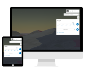
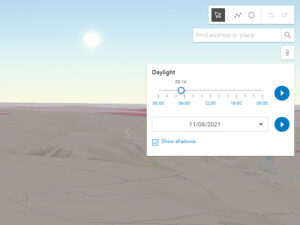
There are a few great drone maps out there, but we haven’t seen any with the variety of data that we offer. Especially the landowner stuff – we spent a lot of time pulling in data with the names, addresses, title numbers and such. It costs us a lot and there’s a huge amount of work behind the scenes to make it usable. Also, there’s cool features like the daylight tool, which shows where sunlight falls on the map at any given date in the year – that’s really useful, especially for photographers and videographers.

Map Drawing ToolWhat am I getting with the paid version?

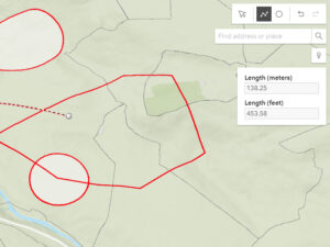
You’re getting all of the landowner data – title number, owner name, contact details. If you’re planning to fly in a new spot but you don’t know who owns the land, this is gold. You also get the ability to draw, measure and save flight plans on your account. The measurements are great for helping you comply with the Drone Code, as you can check distances from built up areas and other potential hazards.

Why do you have to charge?

We don’t charge our users for the stuff we get for free, but some of the best data we have is paid for. We decided early on to prioritise accuracy over cost and we chose trusted, paid for options over unvalidated free versions, so we know the data we have from HM Land Registry and Ordnance Survey is consistent, definitive and authoritative, ie. – it’s correct.

Don’t forget the Microsoft cloud infrastructure: and we’ve got over 100 million rows in our database. There’s a lot of data, it’s a lot of storage, a lot of processing!

I think more importantly to note: we don’t have any advertisements and we don’t sell user data. We only ask for an email address and password. The only way we use this data is to allow users to access the platform, and to add emails to our mailing list. The data doesn’t go anywhere else.

Map Daylight ToolI don’t fly every day – should I upgrade to a paid subscription?

We’ve built the subscription model to be really flexible, so you can upgrade or downgrade at any time. If you’re not flying all year round, there’s nothing to stop you upgrading to plan some flights, get landowner permission, try out all the tools, then downgrade until you need it again.

What’s up next?

We’re about to do a huge update to the landowner portal to make it more intuitive for landowners to add policy information, so expect to see a lot more land opening up for drone use. We’ll also be doing some user feedback sessions again, hearing from the community what’s useful and what’s not. And next year we’ll be launching a mobile application for the map.

Did you say, “Mobile app next year”?

At some point next year, definitely, yes. Just don’t ask me which quarter yet!

Register on the Map

It’s free to register on The DronePrep Map – we just need an email address. Start planning your flights today:

The DronePrep Map

DronePrep Map

DronePrep at the World of Drones & Robotics Congress 2021

DronePrep is delighted to represent the UK at the World of Drones & Robotics Congress 2021. This is our second year, with Co-Founder & CTO Claire Owen also asked to speak at the event on 18-19 August.

This year’s congress will be held both online and in-person at the Brisbane Convention and Exhibition Centre, Australia. DronePrep was approached by the Department for International Trade (DIT) and asked to represent the UK. We will be joining their virtual pavilion.

The World of Drones Congress and Robotics Congress is the largest drone event in the Asia-Pacific region. Visitors can to see the latest industry developments, applications and policies. Bringing together the experts in drones, robotics and autonomous systems, the congress provides a great opportunity to collaborate.

Following successful trials in Cornwall and Scotland, Claire will be discussing DronePrep’s consortia work with Royal Mail. We will also be showcasing drone delivery for medical purposes and discussing the hurdles to overcome. DronePrep is excited to attend this year’s World of Drones & Robotics Congress.

Interested in attending? Use discount code D25PC for 25% off tickets when registering. For more information, check out: https://www.worldofdrones.com.au/
Planning to be there? Get in touch, come see us on the virtual stand.

DronePrep Innovation

The DronePrep Innovation team is championing drone technology in the UK. Working with industry leaders, we are pioneering drone solutions to complex problems. Find out more by clicking here.

Droneprep Logo BW

View from Above: Chris Gorman takes on the RHS gardens

DronePrep pilot in residence Chris Gorman (aka The Big Ladder Photographer) has been as busy as a bee in the gardens of the Royal Horticultural Society (RHS). Since 2018, he has been capturing stunning aerial images of their sites across the UK. Read on for some words from Chris about his experience flying at all five sites, in all four seasons.

RHS Garden Bridgewater, summer. All images strictly Copyright: Chris Gorman/RHS

Working with the RHS

My relationship with the Royal Horticultural Society (RHS) began in 2018. I was asked by the London Evening Standard to find a drone image showing the beautiful colours of the autumn leaves in London. My first thought was to call the RHS and ask if I could come and photograph the stunning colours at Wisley Garden at sunset. They immediately agreed and the resulting image appeared in the paper the next day.

I was invited back to Wisley by the press team to photograph the garden in more detail, an opportunity I relished. A drone allows you to view the garden from a perspective that previously only the garden designer understood.

After several visits to Wisley, I was then asked whether I would like to photograph all RHS Gardens. That meant all four seasons, RHS gardens across the UK: Wisley in Surrey, Rosemoor in Devon, Harlow Carr in North Yorkshire, Hyde Hall in Essex and, more recently, the brand new RHS Bridgewater in Manchester.

RHS Garden Hyde Hall, winter All images strictly Copyright: Chris Gorman/RHS

Planning photoshoots 

The freedom of creativity that the RHS permits when carrying out this work is why the images work so well. I arrange all shoots based on the weather; sunlight is vital for a good shot. With some of the locations involving 400-mile round trips, I need to be confident that the weather is going to play ball when I get there. This summer has tested this to the extreme, with forecasts often changing drastically from one day to the next. I’ve had a few occasions when three different weather apps have been incorrect!

I use DronePrep’s Daylight Tool when planning many of these shoots, it gives me specific information about where the sun is going to be at sunrise and sunset – it’s a feature I absolutely love.

Permission-wise, the shoots are quite easy as landowner permission is already in place with the RHS. The only garden that has airspace issues is Bridgewater in Manchester, due to its proximity to the airport. Manchester Airport has been very helpful so far with permission easily obtained.

RHS Garden Rosemoor, summer. All images strictly Copyright: Chris Gorman/RHS

The resulting images

Many of the images have appeared in the national press, From the Daily Telegraph and The Times to the Daily Mail and Daily Express. As a media photographer with nearly 30 years of experience, I know exactly what a picture editor likes to see. Crucially, an image needs to be pitched to a newspaper at the right time. Even a great picture needs a news hook to hang it on… hot weather, national gardening week, and so on.

The RHS has allowed me to indulge my passion for shadow images. There are some great shots of gardeners watering the flowers and raking leaves, or couples walking hand in hand through the roses.

I love how each garden looks completely different through the seasons, with something new to see from the air on each visit. After around 15 shoots at Wisley over the last three years, I still find something new to capture each time.

RHS Garden Wisley, winter. All images strictly Copyright: Chris Gorman/RHS

Chris’s images of RHS Hilltop can be seen in an exhibition at Wisley Garden in Surrey. The exhibition will run until mid-September.

Images copyright RHS and The Big Ladder Photographer – check out Chris’s work on Facebook and Instagram.

The DronePrep Map

Chris uses The DronePrep Map to help him plan flights and get landowner permission to take-off. Check out The DronePrep Map for everything you need to plan flights safely.

DronePrep Map