The first global digital awards scheme of its kind to recognise positive drone use cases which are innovative, safe and have real world implications.
We are thrilled to be working with our partner Airwards who are on a mission to recognise and award innovative, responsible, and impactful drone use cases around the world.
Standing close to the Tower of London, alongside the historic Royal Mint building, within a few minutes of St Katherine Docks and Tower Bridge, Royal Mint Gardens occupies a significant position in the heart of historic London near to the City of London.
Knight Frank were appointed selling agents of 88 Royal Mint Street last year and were in need of some impressive marketing collateral to showcase this iconic development.
The use of drones in the sale of property marketing is becoming more and more popular. Using a drone is an incredible way to capture footage from a variety of angles and altitudes plus it is cost effective and efficient, however securing all of the necessary permissions, especially in an urban area, can be incredibly difficult.
During the first lockdown period of 2020 we collaborated with a number of stakeholders to achieve the largest ever flight envelope in Zone 1 (400acres) above Grosvenor and Cadogan Estate (read more). This required a number of permissions, including from landowners, NATS, CAA and the Metropolitan Police Commissioner. With our pilot in residence Chris Gorman having the necessary qualifications to fly in a densely populated area and the connections already in place meant that we were delighted to be able to collaborate with Knight Frank to produce this incredible marketing footage:
“Working with DronePrep on this project took away any uncertainty or pitfalls that organising an aerial shoot in such a built up area could potentially cause. The end result was dynamic and detailed footage delivered at a fraction of the cost, and within a shorter time frame, than a helicopter shoot – ultimately providing best value for our client.”
DronePrep Pilot in Residence Chris Gorman (AKA Big Ladder Photographer) has been featured on BBC Breakfast this morning talking about his incredible and unique portfolio of aerial work collected during lockdown:
Currently in the UK there is a lack of conversation between landowners and drone pilots. Landowners are concerned about drone flying (particularly rogue flights) on their land, while pilots often do not know they need permission to take-off, land and overfly on certain areas.
Do you know how many landowners and pilots there are in the United Kingdom?
There are… 220,000 drone pilots and 56 million landowners (CLICK HERE)!! Consequently, getting both parties to communicate is a humongous mission!
Could you class us as the ‘modern day’ hero?
Airspace Growth Programme – The Solution
…DronePrep to the rescue!
We aim to bridge this divide between landowners and drone pilots to create a safe and fully integrated airspace. The tool to achieve this is The Airspace Growth Programme.
So what actually is the Airspace Growth Programme? We are striving to give landowners a way of communicating conditions to allow access of their airspace directly above their land. Once decided (with our help) on what and where they are happy for drone use, we add it to our online platform for all members and drone pilots to see!
This is growing more important everyday. Each location onboarded onto the DronePrep platform unlocks the potential for incredible and innovative projects including future medical drone deliveries, search and rescue efforts and operational and R&D testing.
A well communicated Drone Access Policy opens up huge possibilities for both landowners and drone pilots. It can allow for fun flights for the drone community to obtain beautiful imagery of which can be shared with the general public to help market landowners incredible properties which deserve to be seen.
How to Make Tomorrow, Today – What Next
To make the Airspace Growth Programme thrive, we need yourhelp. If you know of any large landowners including farms and stately homes you can refer them to us to put on our platform. If you register to be a member (CLICK HERE)you can receive up to £25 for every successful land referral and become a Community Hero! What more is there to know? GO GO GO!!
A real student lead course, Geography at the University of Worcester puts you first! Due to the lecturers having a real passion for what they teach it allowed me to find my niche – Drones. This was kick-started from one Phantom 4 Pro demonstration in a Level 4 module of my undergraduate degree.
Take-off : How it Grew
Knowing that my passion lay with drones, I actively sought for as much experience as possible.
Learning and Teaching Project
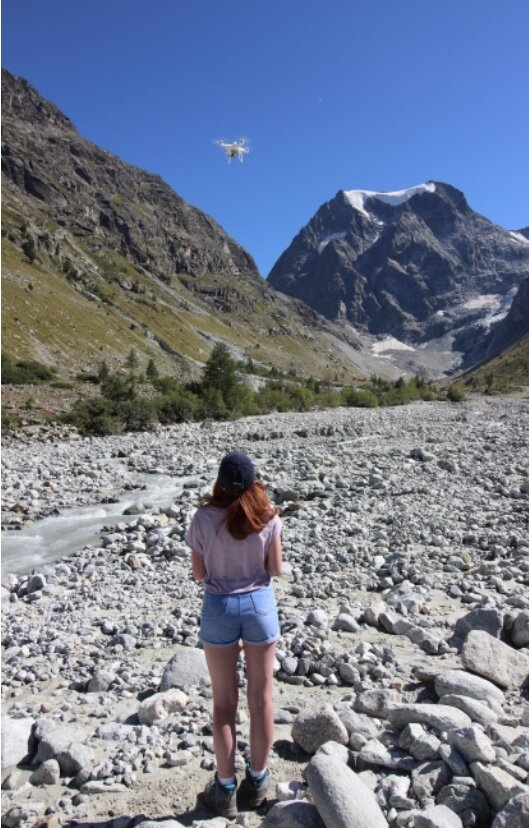
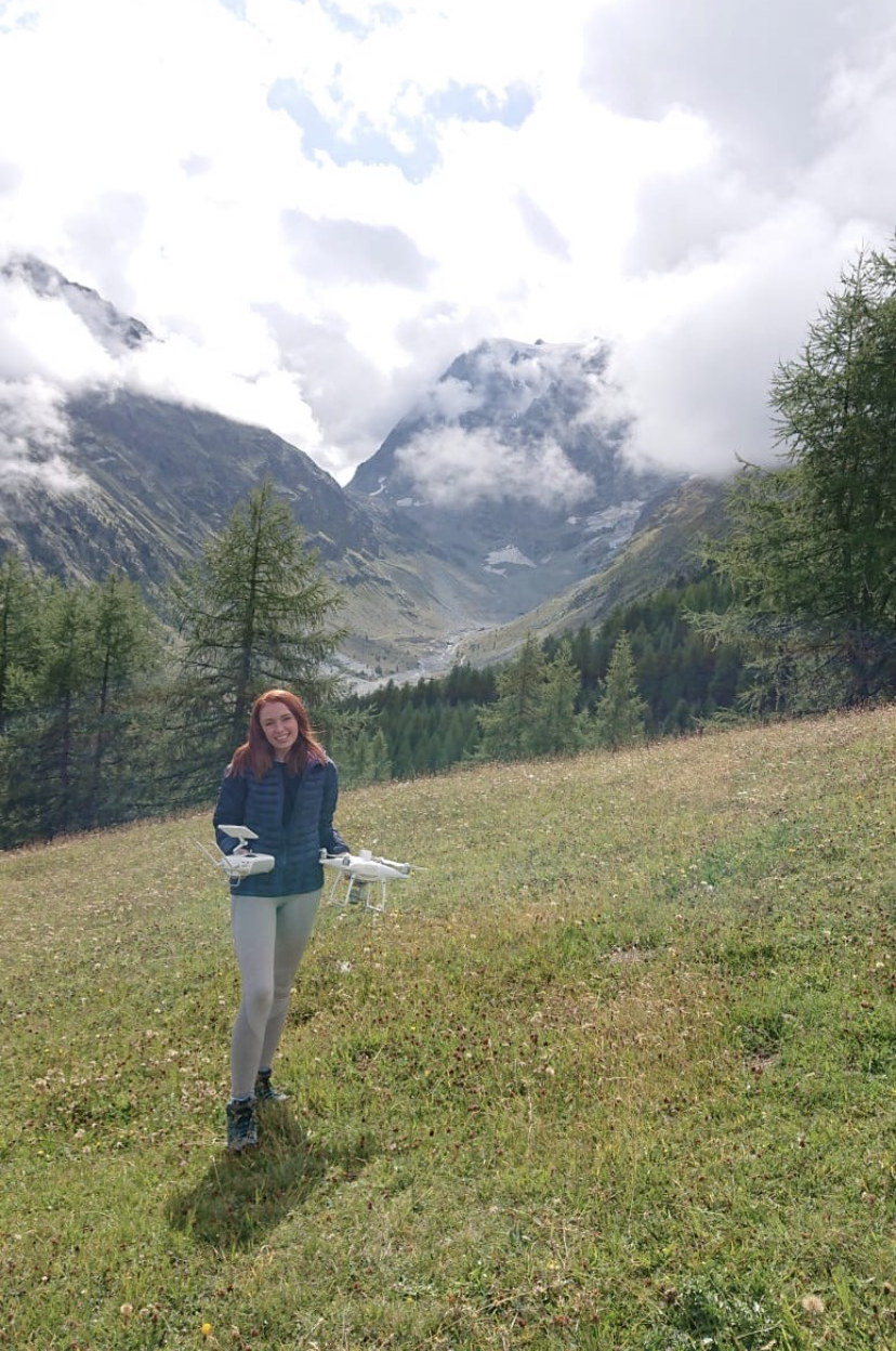
Through a competitive selection process I was chosen to participate in a funded project to aid future students. The project involved travelling to the Swiss Alps to collect drone imagery to be used in practical classes in Level 5 modules. Behind the scenes work for this required: identification of new and suitable sites within the Arolla Valley, obtaining baseline data at each site including the distribution and surveying of GCPs and IVPs with a as well as being a co-pilot for numerous Phantom 4 Pro with onboard RTK flights!
Fieldwork Assistance
If, when and how I could participate in drone fieldwork, I did.
This began with assistance on Masters and PhD students projects. For this I undertook tasks such as laying and surveying GCPs with the Trimble R10 GNSS, setting up and calibrating the drone before flight, experience with the DJI Go App and undertaking supervised flights.
From this my fieldwork experience took off- the most memorable being in the Arolla Valley 2020. Myself and two fellow students on my course aided Senior Professor Ian Maddock in his study of using a Phantom 4 Pro with onboard RTK to measure snow depth. Although the week-long excursion involved a lot of perseverance; walking through 2m snow with non-waterproof boots (not my best idea) and thinking on the spot with the kit constantly failing due to the extremely cold temperatures, it was a lot of fun! I was able to get some incredible flying experience in a totally new environment with people that shared the same passion, this made it all worthwhile.
Student Academic Partnership
Student Academic Partnerships involve a close relationship between lecturers and students to create a project beneficial to all. Our project involved a practical session in the form of a powerpoint, interactive exercises and quizzes to equip undergraduate Geography students with the
knowledge to pass the CAA Drone Safe Drone Code test. Noting the importance of this, we sought to make the practical as fun and inclusive as possible, hoping these key practices stay in their minds for future flights! Due to the current COVID-19 crises the practical has not been implemented, however, I look forward to hearing about its potential success in upcoming years.
Dissertation
Your independent study is all about expressing yourself in your field of expertise- for myself this was a no brainer. My project was titled: Assessing the effectiveness of drone imagery in identifying Channel Geomorphic Units. Undertaken upon a 200m sinuous reach of the River Teme, I conducted supervised flight with a Phantom 4 Pro using a flight plan I generated myself through the DJI Go App. Although this sounds smooth sailing… as with all flights unexpected problems can arise. The growing issue with shared airspace was apparent when I had to quickly move the university drone out of the way of an oncoming military helicopter. Avoiding any near-misses and on return to the office I was able to freely process my dataset of 720 photos in Agisoft Metashape Pro creating fully referenced and high quality orthophotos and DEMs.
Work Placement
A very big step in my UAV career progression was my work placement at Geodime. The placement allowed me to transfer my educational knowledge of UAVs into a working context- meeting real and tight deadlines. My role at Geodime was ‘ Assistant Pilot and Photogrammetrist which saw me working closely with large scale companies such as Hanson, to generate their monthly stock surveys. To achieve this I performed supervised drone flights and processed any datasets through complex softwares such as Klau.
Flight: My Next Steps
Since graduating from the University of Worcester in Summer 2020, I wanted to turn my experience with UAVs into a career. Personally, I couldn’t have found anywhere better than DronePrep to start. It is clear we share the same passions, the want to be a part of this ever changing discipline by helping their integration both safely and effectively into modern society. I look forward to my part in this mammoth task, opening up the airspace bringing landowners and the drone community together.
We are delighted to welcome Emily to the DronePrep team today where she will be working closely with Claire Owen and Gareth Whatmore on growing the DronePrep Airspace Growth Programme.
Emily has recently graduated from University of Worcestershire with flying colours (a 1st!!!) where she has undertaken a number of pioneering projects with the University of Worcestershire Geography Department in the West Midlands, Wales in the Swiss Alps.
Emily’s academic work has seen her work alongside University Project Partners including local Farmers and the Environmental Agency whilst her vocational work has seen her cut her teeth with companies such as Hanson and Geodime.
Emily has a passion for Drone Flying and the Future of the Drone Industry and has tracked DronePrep’s journey for over a year.
On Emily joining, Gareth Whatmore CEO and Co-Founder of DronePrep said:
We are exceedingly lucky to have attracted such a superb Graduate from the University of Worcestershire, with experience and appetite for the growing drone sector, to join us at our new company headquarters at Malvern Hill Science Park. We can’t wait to work with Emily to grow our company mission to open up low-level Airspace for Responsible Drone Use.
When asked about her new role at DronePrep Emily said:
I’m extremely excited to be kick starting my career in UAV’s with DronePrep which has already made some amazing breakthroughs. This opportunity presents a new perspective of the drone industry for myself, I couldn’t be happier to have Claire and Gareth guiding me through. I look forward to the future, learning and growing alongside DronePrep and seeing where the Company takes me!